

ROUTE SELECTION
Q: What are the VFR Cruising Altitudes? Are they based on true or magnetic track?
A: VFR cruising altitude starts at 3,000′ AGL
EAST (000º to 179º) Odd thousand + 500 feet | WEST (180º to 359º) Even thousand + 500 feet
In Southern Domestic Airspace, cruising altitude are based on magnetic track (magnetic heading) and in the Northern Domestic Airspace, cruising altitudes are based on true track
Q:What are the regulations for flying over open water?
A: For land aeroplane when beyond gliding distance from land, life jackets are required (CAR 602.02) For single-engine aircraft beyond 100 nautical miles, life rafts are required. (CAR 602.63)
Q:What is the difference between controlled and uncontrolled airspace?
A: Controlled airspace within which air traffic control service is provided and within which some, or all aircraft may be subject to air traffic control. Uncontrolled airspace there is no air traffic control service.
Q: What are the VFR weather minima for controlled and uncontrolled airspace?

Q: Name all the different classes of airspace. Which one is uncontrolled?
A: Class A, B, C, D, E, F, and G (CAR 601.02)
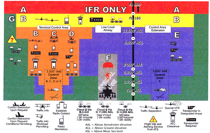
Q: To what class of airspace do low-level airways belong?
A: Low-level airways are Class E up to 12,500′ AGL and Class B from 12,500′ up to bu not including 18,000′ AGL
Q: What is the base of low-level airways? How wide are they?
A: Low-level airways extend upward from 2,200′ AGL, Typically low-level airways are 8 nautical miles wide
Q: Do VFR flights need permission to enter Class E airspace?
A: VFR flights do not require permission to Class E airspace
Q: You intend to fly 800′ AGL in Class G airspace. What are the minimum weather requirements?
A: Below 1000′ AGL in uncontrolled airspace:
2 miles visibility by day, clear of clouds | 3 miles visibility by night. clear of clouds
Q: What is the major difference between Class E and Class G airspace?
A: Class E airspace is controlled: weather minima are higher and ATC may exercise sone authority
Class G airspace is uncontrolled: weather minima are lower and ATC has no authority
Q: Can you fly through Class F airspace?
A: Yes if Class F airspace is ADVISORY (CYA) |No if Class F is RESTRICTED (CYR)
Q: What are the factors for choosing a route?
A: – Presence of large body of water
– Type of Airspace
– Proximity to other airports in case of diversion
– Visible landmarks
– Fuel considerations
Q: What are the factors for choosing Altitude?
A: – VFR cruising altitudes regulations
– Verification of MEFs in each quadrant along the intended route
– Verification of MOCA, that is the minimum ASL altitude which ensures that you will be clear of obstructions
– FD
Q: How to determine the highest maximum elevation figure along your route? What is you MOCA?
A: Check MEFs in each quadrant along your route to determine which is the highest. Locating the highest obstruction, will help you determine your MOCA, which is the minimum altitude ASL the will clear obstruction by 1000′
WEATHER INFORMATION

Q: Which weather information was used to plan for the expected runway at your destination?
A: METAR and TAFs
Q: What does NOTAM stands for? How do you get the NOTAMs for the proposed cross-country?
A: Notice To Air Men. NOTAMs are issued 5 hours in advance and are distributed to FIC. (TC AIM MAP 5.0 PAGE 347)

Q: Why is it considered good practice to obtain current weather information to the west (and north-west) of the area where the cross-country flight is to take place?
A: As weather systems generally move from west to east, there is a good chance that the weather conditions that currently exist to the west will have moved further east by the end of your flight. It is also a way to confirm if the forecast (GFA and TAF) are accurate.
NAVIGATION CHARTS
Q: What is the scale of the VNC and VTA chart?
A: VNC = 1:500,000 | VTA = 1:250,000
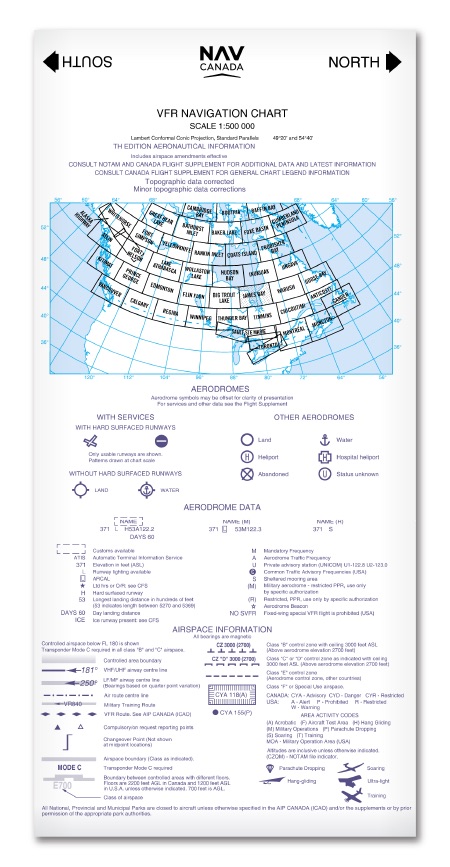
Q:How do you know if your VNC or VTA charts are valid? How can you check if changes have occurred to the chart since they went into print, and if the next issue is not yet printed?
A: Check NAV CANADA website for current issue. Any changes VFR charts are located in the Canada Flight Supplement under section C.
Q: What is the purpose of 10 degree drift lines?
A: Allows us to accurately and easily estimate how many degrees we are off track while navigating without using instruments, such as a protractor , during flight.
Q: Name three techniques that can be used to get back on track
A: – Visual Alteration
– Double track error
– Opening and closing angles
Q: Name the three different types of “set heading” procedures and describe w\hen you would use them
A: Overhead departure provides a known fix for starting, something particularly useful where the airport is surrounded by miles of featureless terrain or the visibility is limited.
Geographic point procedure lets you set your heading at a distinct landmark a short distance away. Often used when departing from busy airport or those with airspace restrictions.
En route climb lets you take off and reach a safe altitude before turning to intercept your track and climb en route. It is quick and direct, although sometimes it is difficult to determine when you are established on track.
OPERATIONAL INFORMATION AND CONSIDERATION
Q: What is the difference between MF and ATF?
A: (ATF) Aerodrome Traffic Frequency is normally designated for active uncontrolled aerodrome to ensure that all radio-equipped aircraft operating on the ground or within the are are listening on a common frequency and following common reporting procedures.
(MF) Mandatory Frequency is used at selected uncontrolled aerodrome, or aerodromes that are uncontrolled between certain hours.
Q: How do you enter an uncontrolled airport?
A: – It is recommended to join the circuit from the upwind side
– If no possible conflict exists, it is also allowed to join straight into the downwind.
Q: How do you enter controlled airport?
A: – Initial contact must be made prior operating in any control zone. If the control zone is Class C or D, you must receive a clearance prior to entry.
Q: What are the requirements for special VFR?
A: One mile visibility | Clear of clouds
Q: If you are unsure of runway conditions at your destination, what could you do?
A: Check CFS for winter maintenance and NOTAM or contact the airport operator
Q: When calculating crosswind components, why must you apply the variation to the wind?
A: Runway is the Southern Domestic Airspace are magnetic but winds in METAs are true. Therefore, it is necessary to apply the local variation to the winds if using METAs for your calculation.
Q: How do you obtain DF steer?
A: First check in the CFS or the aerodrome data box on your chart to see if DF steers are available. Then contact the appropriate agency to request DF steer.
Q: How do you know if your CFS is current?
A: The front cover displays the validity date
FLIGHT PLANNING LOG
Q; What does pressure altitude mean? On what altitude are most performance charts based?
A: Pressure altitude is the altitude corrected for non-standard pressure. Most performance charts are based on the pressure altitude.
Q: Define the following IAS, CAS, TAS
A: (IAS) Indicated AirSpeed is what you read on the instrument
(CAS) Calibrated AirSpeed is IAS corrected for instrument and position error
(TAS) True AirSpeed is CAS corrected for non-standard pressure and temperature
Q: What is true track?
A: The track that the pilot intends to follow over the ground, as drawn on the chart. It is measured in degrees true.
Q: What is variation?
A: The angle between the true meridian and the magnetic meridian
Q: What is the difference between magnetic track and the magnetic heading?
A: Magnetic track is the true track plus (if westerly) and minus (if easterly) variation.
Magnetic heading is the magnetic track with the wind correction.
Q: What is deviation?
A: The angle through which the compass needle is deflected from the magnetic meridian caused by the metal in the airframe and engine, and instruments.
Q: What is compass heading?
A: Compass heading is the magnetic heading corrected for the deviation. It is the heading that the pilot will follow in flight
Q: What are the minimum fuel requirements for day VFR / night VFR flight?
A: Day VFR to destination + 30 minutes at normal cruising speed | Night VFR to destination + 45 minutes at normal cruising speed (CAR 602.88)
FLIGHT PLANS
Q: What is the difference between a flight plan and a flight itinerary?
A: Flight plans are filed with ATC, FIC, FSS, over the internet at navcanada.ca or Community Aerodrome Radio Stations.
Flight Itineraries are filed with a responsible person.
Q; When are you required to file one of the above?
Q: With whom do you open and close a flight plan?
A: If flight exceeds 25 nautical miles from the departure aerodrome
Q: Why is it important to note your takeoff time?
A: Without takeoff time, you have no way of knowing when your flight plan expires. Also, if you get lost, you will not be able to accurately calculate the total fuel burned.
